The 12 Original Counties of New York State
by Cliff Lamere 20 May 2006
![]()
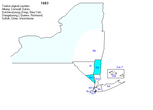
On November 1, 1683, the Province of New York was divided into 12 counties.
Only 10 of the counties included land that is currently within New York State.
Those 10 counties were as follows.
1) Suffolk Co. - made up most of Long Island, as it still does.
Numbers 2-4 are all part of New York City today.
2) New York County (the island of Manhattan). This is the NYC borough of Manhattan.
3) Kings County. This is the NYC borough of Brooklyn.
4) Richmond County. This is the NYC borough of Staten Island.
5) Queens County. This county was split to form the present Queens County and Nassau County. The present Queens County makes up the borough of Queens in NYC.
6) Westchester County. This county was split to form the counties of Westchester and Bronx.
Bronx Co. makes up the Bronx borough of NYC. It is the fifth and final borough of NYC.
7) Duchess County (now spelled Dutchess) was named after the Duchess of York. Putnam Co. formed from the southern part of Dutchess Co.
Two southwestern Towns of Columbia Co. also were once a part of Dutchess Co.
8) Orange County on the west side of the Hudson River. Rockland County later formed from land taken from Orange Co.
9) Ulster County on the west side of the Hudson River. Parts of it were removed to form Sullivan County, part of Delaware County and part of Greene County.
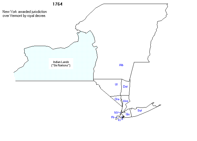
10) Albany County was much larger originally. It included all of the land north of the other counties, and extended to today's northern limits of the state.
It included all of Vermont for awhile. It extended westward to the middle part of the state, beyond which were the Indian lands.
Two other original counties claimed land beyond the present boundaries of New York State:
11) Dukes County. This claim was to many coastal islands (Martha's Vineyard, Nantucket, the Elizabeth Islands) that were far east of New York and later became part of Massachusetts.
12) Cornwall County. Part of what is now Maine, in 1692 it became part of Massachusetts.
![]()
1683
[The speckled area is the area that was controlled by Indians.
Cornwall and Dukes Counties are no longer part of New York State]
![]()
1764
[Albany County made up the vast majority of the state as it existed in 1764. Vermont, on the east, was part of Albany County at that time.
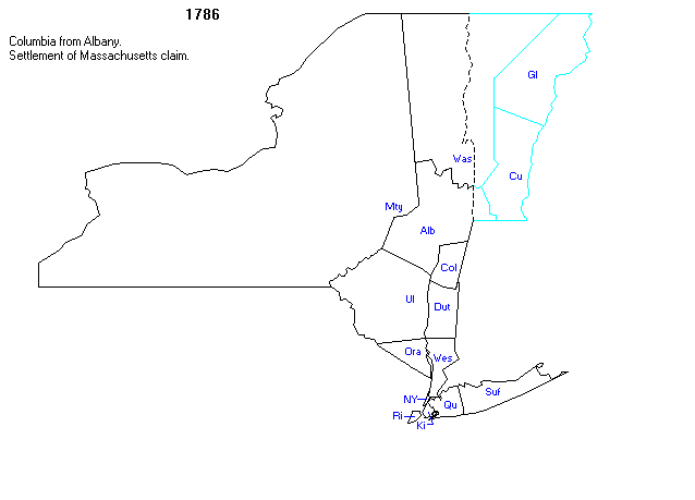
1786
[In 1772,
Tryon County formed from the western part of Albany County. The Indian
Lands continued to shrink westward.
Around
1777-1778, Massachusetts claimed most of the Indian Lands. In 1782, Tryon
County was extended to the western edge of modern New York State. In 1784, Tryon County got renamed as
Montgomery County.
In 1786, there was a settlement of the
Massachusetts claim.]
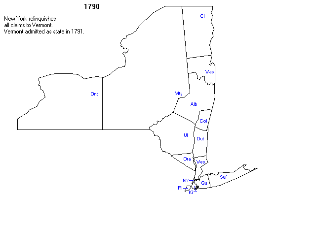
1790
[The final shape of New York State
was established by 1790, the year that western New York was divided from
Montgomery County to form Ontario County. North of New York City, many of
the counties had not yet attained their final shapes.]
You may wish to refer to
a very good map of modern New
York State which shows all counties.
![]()
![]()
![]()
![]()
Visitors since 21
May 2006